Categories
Chart Europe R Switzerland

Veränderung der Durchschnittstemperatur in der Schweiz (1900 – 2020)

Hier noch eine Version ohne Animation:

Und hier noch eine Grafik, welche es nicht in den Abschluss-Post geschafft hat, deshalb auch nicht so toll aussieht:

Zum Abschluss noch ein Bild, welches ich ebenfalls für Tauchstation gemacht habe, allerdings für eine Story. Es zeigt, wie die 0-Grad-Grenze, also die Höhe, wo die Wintertemperatur im Schnitt 0-Grad ist, immer weiter den Berg hochwandert. Es handelt sich um einen Schweizer Schnitt und nicht um die Temperatur am Berg genau.

Categories
Chart Europe History

The Reign of Roman Emperors

I visualized the reign and end of Roman emperors. I am quite a fan of history, so when the task in the /r/dataisbeautiful-DataViz-Battle was to visualize the reigns of the Roman Empire, I was excited.

Categories
Chart Europe Population

To which European countries do Europeans migrate?


Migration is a huge topic in Europe and I wanted to know where people go, when they leave the country they grew up in. Luckily Eurostat has some Data about that.

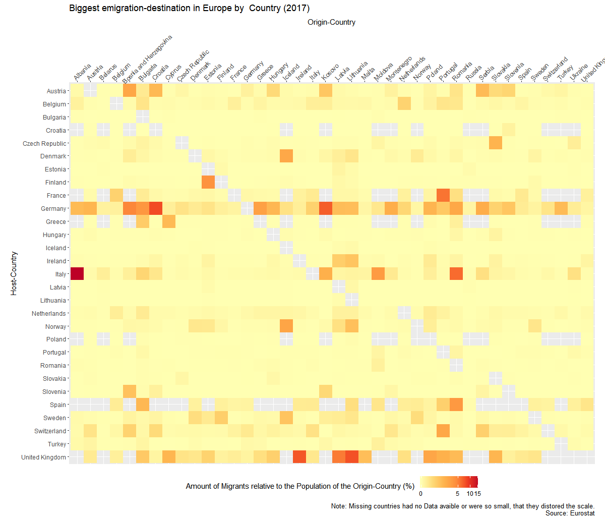
There is the problem of huge population differences between the countries, so I wasn’t able to just use the absolut numbers. So I created to graphs. Once it show the migrant-population  relative to the host country and once relative to their origin country.


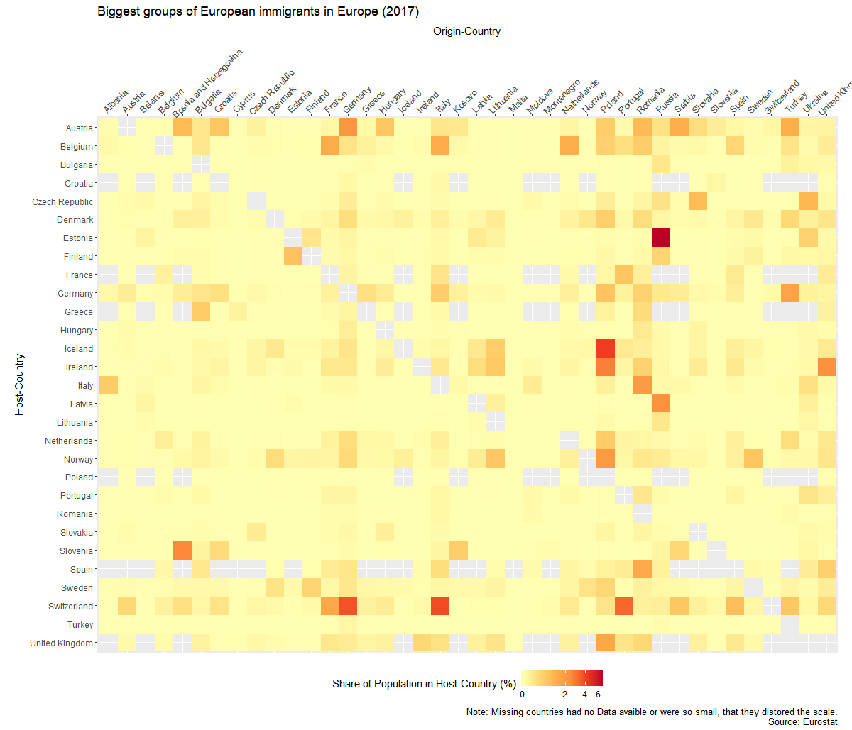
I created the graphs with the help of R and Ggplot. Code of the second graph:

ggplot(mig1,aes(y=Host,x=Origin,fill=sharehostpop))+
 geom_raster()+
 theme_gray()+
 coord_equal()+
 scale_fill_distiller(palette="YlOrRd", direction = 1,na.value=NA,trans='log1p')+
 theme( 
 axis.text.x=element_text(angle = 45, hjust=.1),
 legend.position = "bottom")+
scale_x_discrete(position="top")+
 scale_y_discrete(limits=names(table(droplevels(mig1$Host)))[length(names(table(droplevels(mig1$Host)))):1])+
 labs(y="Host-Country",x="Origin-Country",fill="Share of Population in Host-Country (%)",
 title="Biggest groups of European immigrants in Europe (2017)",caption="Note: Missing countries had no Data avaible or were so small, that they distored the scale.
 Source: Eurostat")
Categories
Europe Fun Map Population

A dot-map of Europe

This map is a more leaning on the aesthetic- then data-side. The size of the dots correlates with the size of the population in that place. The color has no meaning and is just there to look nice. For the division of places I used the NUT3 standard which is quite useful, but has its problems if you use it to compare countries.

Categories
Europe Fun Map

Where have I been in 2017

I created this animation in the first days of 2018. A few years ago I accepted that most of my data is stored somewhere. Instead of avoiding this like before, I started to embrace it. In Google Locations for example all the places where you have been are stored (if you didn’t disable it). It can be quite useful to remember what you did a certain day.

This data can also be downloaded and analysed. I didn’t do that, I just wanted to make a nice animation. To do thso at I imported the data it into R with the help of the json-Library. I just chose one value for each day and exported that new data. The next steps could have been done in R too, but I was less experienced with the program back then.

I imported the data to QGIS instead. With the help of the TimeManager-Plugin I exported a frame for each day. I loaded those into Hitfilms Express, which is a fantastic free video-editing software. I used gifmaker.me before to create Gifs, but they have a limit of 300 frames. I exported the video and uploaded it to Gfycat. And here it is.


Categories
Chart Europe Population

Growth of European Countries relative to 1950


How did the populations of European countries grow after the end of the 2nd world-war? To answer this question I downloaded population-data from the United Nations. I picked 1950 as my default year and looked how it developed from there.

Categories
Europe Map

Population Density in Europe

This map was made with the help of the data of Eurostat. The subdivisions of the countries follows NUTS 3 standards. I used a quantil-scale, which means each colors has about the same number of regions.

Categories
Chart Europe Germany Population

Which European country has the highest share of foreign born population?


For this graph I was interested in which countries had the highest immigration in recent times. I used data from the European Census 2011. Unfortunately the data is a bit old and there doesn’t exist a new version yet. Because Asia can mean a lot of things, I checked from which countries the most people come from. I didn’t count Russia as Asian here.

Because the numbers are quite old, I looked into recent numbers from Germany, where many would expect the most change. I found the Data on the website of the federal bureau for statistics. Unsurprisingly the number of immigrants has risen.


Categories
Europe Map

How much do the countries of Europe invest in R&D?

I created this map some weeks ago with a dataset from the OECD. I wanted to visualize the role of research and development (R&D) in different European countries. The results aren’t to surprising: There seems to be a correlation with the wealth of the country. Switzerland is the country which spends the most on R&D.

Colors and the number of the countries have a different meaning, which is rather confusing.  I tried to put more information on the map, but I have to think of a better way in the future. And I made two mistakes: I didn’t show clearly  that the was no data for Ireland and I used a map-shapefile which labeled the Krim as Russian territory.